

Karachi air quality map
Live air pollution map of Karachi • 302.8K Followers • 15:00, Jun 04 Local time


Stations
Clean Air Facilities
Contributors
Government
0Diplomatic
0Non-profit
3Education
0Corporate
4Healthcare
0Hospitality
0Individual
4Top contributors in Karachi
Who is sharing outdoor air quality data in Karachi?
Featured station
Discover some of the best station installation in Karachi
Station gallery

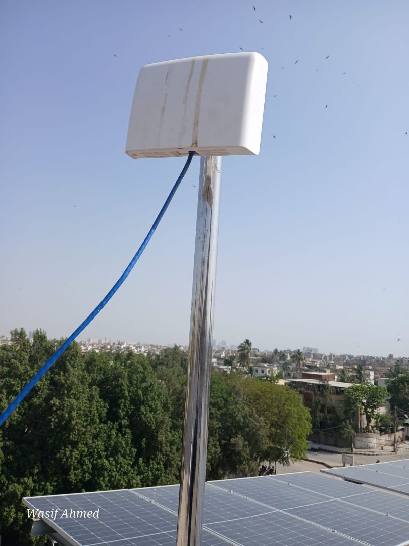
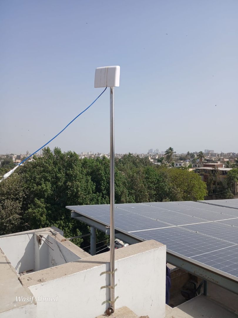
TPL Insurance, Karachi
92
Newest stations deployed in Karachi
AQI⁺ station rankingNewest stations


Learn more about global air quality


Learn more about air pollution in Karachi
Does Karachi have bad air quality?
Karachi is a city located in Pakistan, being one of the largest in the country as well as the 12th largest city worldwide, with nearly 15 million inhabitants living within the city’s limits. A large amount of Pakistan's economy relies on Karachi, and with a high level of industry as well as people living there, Karachi will subsequently suffer from the pollution related issues, as all densely populated and rapidly developing cities often do.
In 2019 Karachi came in with a PM2.5 reading of 40.2 μg/m³, putting it into the ‘unhealthy for sensitive groups bracket’, which requires a PM2.5 reading of anywhere between 35.5 to 55.4 μg/m³ to be classed as such. PM2.5 refers to particulate matter that is 2.5 micrometers or less in diameter, making it 3% the size of a human hair, and as such extremely damaging to human health when respired, hence why it is used as a major component of calculating the air quality as well as pollution levels.
Karachi's 2019 reading of 40.2 μg/m³ put it in 231st place out of all the most polluted cities worldwide, as well as being the 9th most polluted city in Pakistan. Despite being so densely populated, and with a whole host of pollution problems, with some months coming in with dangerous levels of PM2.5 readings, there are cities in Pakistan with considerably more severe pollution levels. However, as it stands, Karachi does indeed have pollution issues with its air that should not be overlooked
What are the main causes of pollution in Karachi?
With such a densely populated city, there is always the accompanying high level of vehicles of all types to come along with the citizens. Many bikes, cars and trucks populate the roads, with a large amount of them being far under what would constitute a safe level of pollution output (due to factors such as vehicle age, as well as the fuel they run on). Many of these vehicles would still run on diesel fuel, which can cause far more elevated levels of pollution in the exhaust fumes than their cleaner counterparts often would.
Besides cars and motorbikes, rickshaws running on two stroke engines (a type of engine that has a high-power output to weight ratio, however due to the design nature they often have mixtures of oil as well as fuel in them, thus creating far more pollution that a four-stroke engine) contribute massively to pollution levels. Other sources include the open burning of refuse and garbage, much of which can contain dangerous materials such as plastic and other synthetic man-made products, as well as organic materials that also releases its own plethora of smoke filled with pollutants. Further contributions come from factory emissions as well as dust from poorly maintained roads and construction sites, which can add heavily to the PM2.5 and PM10 count.
What type of pollutants would you find in the air in Karachi?
With pollutive sources such as vehicles being large offenders for air pollution levels, particularly the ambient ones that are seen year-round due to personal vehicle use being a constant, high levels of compounds such as nitrogen dioxide (NO2) and sulfur dioxide (SO2) would be found in the air. Nitrogen dioxide is of particular pertinence due to the large amount of it given off primarily by vehicles (as well as it being found in open burn sources and industrial emissions), so much so to the point that high levels of nitrogen dioxide in the air will often directly correlate with a large amount of traffic.
Other materials and compounds would include ozone (O3) and carbon monoxide (CO), as well as particulate matter such as black carbon, which can be created through the incomplete combustion of fossil fuels as well as the burning of organic matter.
It is often found as a major component in soot and thus will be seen coating large amounts of roadside areas that witness high volumes of traffic. Others would include finely ground silica dust from construction sites, volatile organic compounds (VOC’s) and benzene, formaldehyde as well as furans, dioxins, mercury, cadmium and lead, the latter of which are released through the burning of plastic materials, as well as any industrial process that uses plastic in its production line (plastic recycling plants or factories that produce plastic containers, casings or goods).
When is pollution at its worst in Karachi?
Observing the data taken over 2019, pollution seems to find itself highest at the beginning and end of the year, a trait which is mirrored in all cities in Pakistan. The cleanest months are April through to June, with numbers of PM2.5 coming in at 18.2 μg/m³ in April, 16.1 μg/m³ in May (making it the cleanest month of the year) and 18.1 μg/m³ in June.
After this, levels of PM2.5 went up gradually, indicating that the amount of smog, haze and smoke would be far more prominent in the atmosphere. October saw a leap up to 44.9 μg/m³, followed by 67.1 μg/m³ in November and 75.9 μg/m³ in December. The month that came in with the absolute worst levels of pollution was January, with a reading of 86.7 μg/m³, putting it into the ‘unhealthy’ ratings bracket. This means that air at this time of the year would be extremely dangerous for all sections of the population to breathe.
Is air quality improving in Karachi?
Observing the date from years past, it appears that pollution levels in Karachi are actually getting worse rather than improving. In 2017, Karachi came in with a PM2.5 reading of 38.5 μg/m³, and then followed with a slight improvement of 33.7 μg/m³ in 2018. This of course was followed by the more recent reading of 40.2 μg/m³ in 2019, which shows that overall levels of year-round pollution have indeed gotten worse.
This would be due to the lack of any significant changes to polluting sources, and if Karachi is to see improvements in its level of pollution, initiatives such as the fining of over polluting factories, home businesses or open burning offenders would go a long way to reducing pollution levels and getting large amounts of dangerous chemicals out of the air. Other initiatives would include the eventual removal of ancient vehicles off the road and a move over to cleaner fuel sources.
Where is the cleanest air quality in Karachi?
- TDF MagnifiScience Centre33
- Zafar Memon DHA37
- G3 Engineering Consultants karachi55
- Aga khan University Main Campus57
- Climate Action Center61
- Jamkanda64
- fazlee sons private limited64
- RT2-230469
- Dawlance Pvt Ltd73
- KLN Freight Pak (Pvt) Ltd73
- Clifton Block 1 C KHI75
- Tariq Road C KHI75
- TIP City Office - LIH77
- Faisal Cantonment A KHI79
- WWF-Pakistan Karachi Office88
- TPL Insurance92
- DAWN Media96
- Urban Resource Center98
- Jamshed Road C KHI107


