

Victoria air quality map
Live air pollution map of Victoria • 107.1K Followers • 05:00, Jun 09 Local time


Stations
Clean Air Facilities
Contributors
Government
2Diplomatic
0Non-profit
0Education
0Corporate
0Healthcare
0Hospitality
0Individual
13Top contributors in Victoria
Who is sharing outdoor air quality data in Victoria?
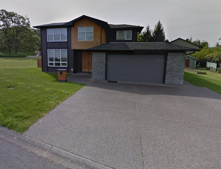
Featured station
Discover some of the best station installation in Victoria
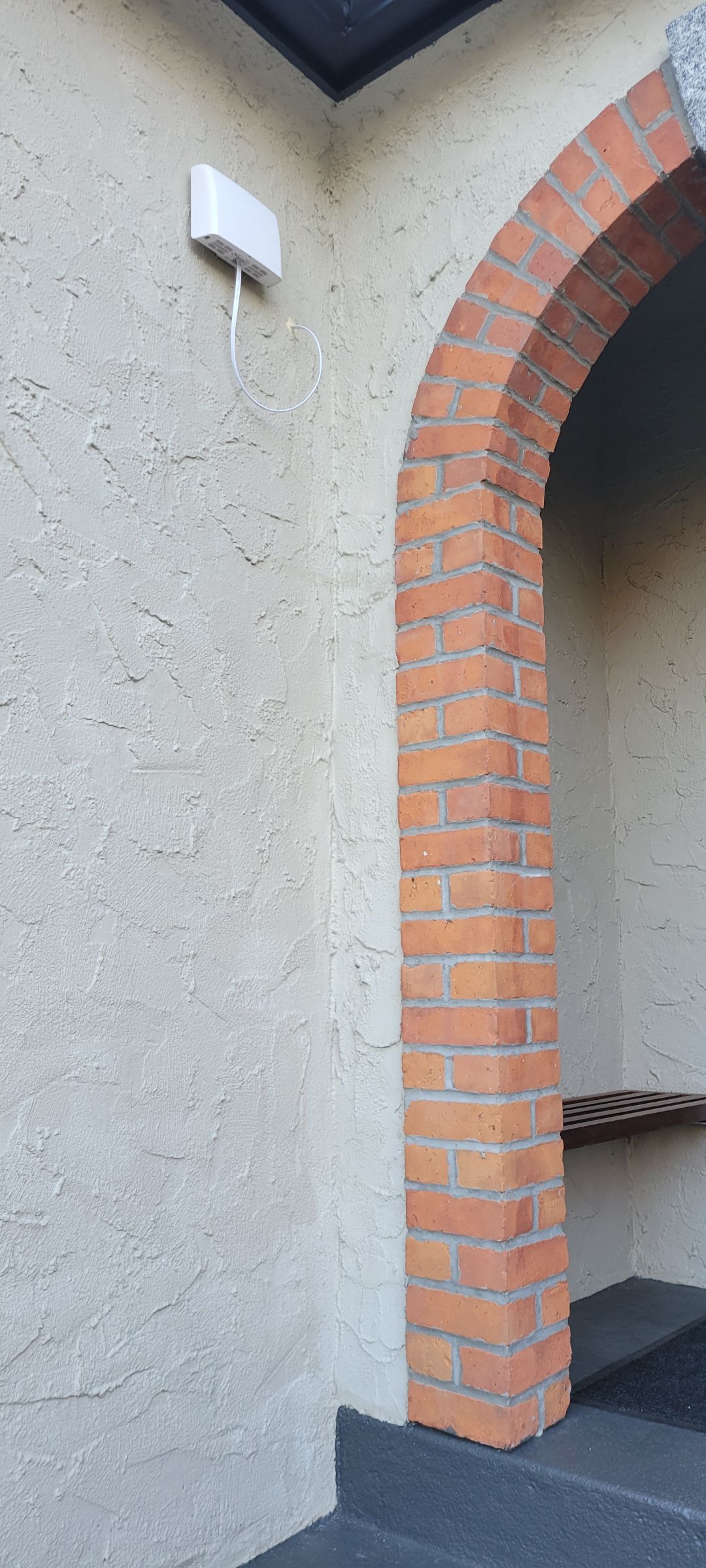

Station gallery

Blenkinsop at Union, Victoria
26
Newest stations deployed in Victoria
AQI⁺ station rankingNewest stations

Clean Air Facilities


Learn more about global air quality


Learn more about air pollution in Victoria
What is the air quality index of Victoria Topaz?
Victoria is the capital city of the Canadian province of British Columbia, on the southern tip of Vancouver Island off Canada's Pacific coast. In 2016 the city had an estimated population of 367,770 people.
At the beginning of 2021, Victoria was enjoying a period of “Good” quality air with a US AQI reading of just 12. This is in accordance with suggested levels by the World Health Organisation (WHO). The recorded levels of the pollutants were as follows: PM2.5 - 3 µg/m³, nitrogen dioxide (NO2) - 11.3 µg/m³ and sulphur dioxide (SO2) - 1.3 µg/m³. With a level of air quality as low as this, door and windows can be opened to allow the ingress of fresh air and all outdoor activities could be enjoyed without fear.
Does the level of air quality differ in Victoria Topaz throughout the year?
During the autumn, Victoria can be subject to the polluted air caused by wildfires in the US. Wildfire smoke carried north from blazes in Washington State, Oregon and California.
In summer, smog is mainly composed of ground-level ozone and fine particles. The high densities of smog are often associated with the summer season by the presence of sunlight and high temperatures, two factors essential to its formation.
Ground-level ozone is formed from the reaction between volatile organic compounds (VOCs) which mainly come from transport and industries, and nitrogen dioxide (NO2) under the effect of solar radiation which comes from transport.
Fine particles, for their part, come mainly from industrial emissions (agriculture, construction) and vehicle emissions.
In winter, smog is mainly composed of fine particles, low temperatures and ultraviolet radiation do not favour the formation of ground-level ozone. Winter smog is a rather local phenomenon that is amplified by extreme cold and which occurs when the air is stable (light wind). Fireplaces and wood-burning stoves are responsible for more than 60 per cent in winter. Automobile transport and de-icing salts, suspended in the air when cars pass, also contribute to degrading air quality.
What is the main source of air pollution in Victoria Topaz?
Air pollution can have local and regional impacts such as ground-level ozone (O3) and wood smoke. It can also have wide-reaching, global effects such as climate change and depletion of the ozone layer. Air pollutants can be visible (e.g., the brownish-yellow colour of smog) or invisible.
The amount of vehicles using the road as a daily commute is also a source of carbon monoxide (CO) emissions. Carbon monoxide comes from the incomplete combustion of organic materials, such as gasoline, diesel, wood, propane, natural gas, fuel oil (heating oil), naphtha, kerosene or coal. For example, it can come from a motor vehicle (automobile, motorcycle, etc.), from a heating device (furnace, fireplace, etc.), or from a combustion engine device (mower, snow blower, saw, etc.)
Burning wood emits pollutants into the air we breathe, especially when poor combustion techniques and inefficient or poorly maintained heaters are used. Only wood that is at least 2 years old should be burnt in a domestic wood burning stove or any prepared wood that has been kiln-dried. It is the high moisture content that contributes to the poor burning of damp wood.
What can be done to improve the air quality in Victoria Topaz?
Data shows that air quality in British Columbia is gradually improving thanks to past and present policies as well as technological developments. However, high concentrations of air pollution continue to have significant repercussions on health, with particulate matter (PM), nitrogen dioxide (NO2) and ground-level ozone (O3) pollutants the most harmful.
If you buy a log burner, use a stove or fireplace that has a US Environmental Protection Agency (EPA) or the Canadian Standards Association (CSA) approval sticker. This sticker certifies that the device emits up to 95 per cent fewer particles and is up to 20 per cent more energy-efficient than conventional models.
Burn only seasoned wood, and never burn garbage or treated wood.
What are the effects of breathing Victoria Topaz’s poor quality air?
The effects of air pollution on health are determined by the duration of exposure, the concentrations of pollutants as well as the state of health of the exposed persons.
Not all groups of people are at the same level of risk due to polluted air. The following groups are more susceptible than strong healthy adults.
- children (because their respiratory system is still immature);
- the elderly (because they are more likely to suffer from health problems such as lung or heart disease);
- people with respiratory problems (asthma, chronic bronchitis, COPD, emphysema, etc.);
- those suffering or having suffered from cardiovascular problems (angina, myocardial infarction);
- people with heart failure, arrhythmia or other heart conditions;
- people with chronic illnesses, such as diabetes, rheumatoid arthritis or lupus;
- those practising outdoor sports;
- people who work outdoors on a regular basis (especially if contaminant levels are high at a specific time or in their living environment (near sources of pollutants, such as road traffic, industrial areas, etc.).
The main symptoms that are often associated with short-term exposure are irritation of the respiratory tract. The worsening of symptoms in people with cardiorespiratory diseases such as asthma, bronchitis or emphysema.
Wheezing is more prevalent as is a sensation of tightness of the chest. Affected people often find it difficult to breathe normally and often experience pain at the same time. Death can occur prematurely, especially for people with pre-existing cardiorespiratory problems.
Exposure over a longer period can have detrimental effects on lung capacity with accelerated ageing and the formation of scar tissue. Children’s lungs may not develop properly due to the polluted air that they breathe.
Pregnant women are vulnerable too because through long term exposure they may give birth prematurely to a baby with a lower than normal birth weight.
If you are part of a vulnerable group and have to do outdoor activities (exercise, work, gardening), choose times when air pollution is lower, for example in the morning. Do not exercise near busy roads, in industrial areas, or at peak times. Wearing a good quality mask will help filter out some of the particles.
Make a habit of checking the air quality index in your area daily. If you know in advance that the air quality will be bad, you can plan your day accordingly.


